
« The Dirty Wash | Main | Advancing Search »
September 25, 2008
Thunder Bay Trip
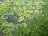
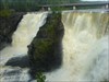
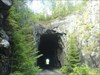
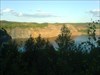
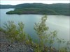
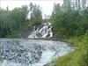
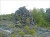
I took a some time off at the beginning of September to make a little excursion with my Dad out to Thunder Bay and back. I've never travelled east of Kenora or Fort Frances and not recently or much at all. We started out east on Hwy 17 to Thunder Bay and ended up stopping at both Dryden and Kakabeka Falls for the night. I managed to snag an EarthCache in Ontario so I would qualify for the EarthCache Masters program. Along the way we stopped at quite a few caches, mostly roadside rest stops, but did take some time to pick up a few of the Dryden caches. I was more determined to snag the "Grand Trunk" cache as it was a FTF and it sounded like a very interesting location. It took some time and effort but it was found and it was a great cache. We didn't end up spending much time in Thunder Bay, I did manage to find a nice Marsh after we got lost. There were some really nice caches in the marsh and it was enjoyable to walk around to find them all. It was also a great place to drop the travelbugs I was carrying and pick up one for the trip back. My GPS maps seemed to be quite outdated for Thunder Bay, they were missing a major highway reroute, a couple other roads and some bridge openings and closings. On the return trip we took the southern route on Hwy 11, dubbed MOM's way by tourism staff. It's pretty deserted wilderness for the most part until you get to the US border. Not many caches out that way either, so even with stopping at all of them along the road, we traveled quite quickly. We stopped for the night at Atikokan, the site of an old open pit iron mine. Just before sunset we spent some time driving out to the mine and all around it, looking for some views and some caches. The pit is still something to look at, but it's getting over grown and it's filled up with water. The old asphalt road surface was interesting to study as it's degraded over the years but is largely intact. The earth is so ladden with iron ore that it's the rusty red brown orange color, and it's quite odd to see plants and trees growing out of large piles of it. There weren't many caches at all the rest of the way to the US border then through the US and back into the Manitoba, even along Hwy 12 in Manitoba there really aren't any caches. Even so, we did stop at most of the caches and there were some memorable and interesting ones. There certainly is one that has a story that I won't repeat here. I finally managed to find a benchmark, I've looked for quite a few in Canada that just weren't findable. That was the last of many little check boxes on my geocaching todo list that I managed to check off on this trip. An interesting tidbit, the Canada Customs agent knew about geocaching and had found some in Ottawa but hasn't done any in Manitoba. One of the more odd things that I didn't realize before the trip, Rogers has no cell coverage over most of the area we traveled. There is also one GSM provider in Dryden that Rogers doesn't roam on which gave me a "Inactive SIM" message. Even though I was only out of coverage for a couple days at a time, I never received any of my SMS or voicemail messages when I emerged back into service areas.
Continue reading for some pictures from the trip.
Click for the log with picture and then click the picture from the log for an even larger one.
 |  |  |  |
 |  |  |  |
Comments
Post A Comment
Created By: Steven Nikkel (steven_nikkel@ertyu.org)
This webpage and others materials are Copyright © 1997-2016 Steven Nikkel, All Rights Reserved
